


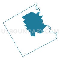
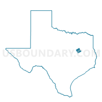
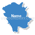
Voting District 0001, Freestone County, Texas
About
Outline

Summary
| Unique Area Identifier | 673226 |
| Name | Voting District 0001 |
| County | Freestone County |
| State | Texas |
| Area (square miles) | 207.68 |
| Land Area (square miles) | 203.69 |
| Water Area (square miles) | 3.99 |
| % of Land Area | 98.08 |
| % of Water Area | 1.92 |
| Latitude of the Internal Point | 31.78255870 |
| Longtitude of the Internal Point | -96.09362130 |
Maps

Graphs
Select a template below for downloading or customizing gragh for Voting District 0001, Freestone County, Texas


Neighbors
Neighoring Voting District (by Name) Neighboring Voting District on the Map
- Voting District 0002, Freestone County, TX
- Voting District 0008, Freestone County, TX
- Voting District 0011, Anderson County, TX
- Voting District 0011, Freestone County, TX
- Voting District 0012, Anderson County, TX
- Voting District 0012, Freestone County, TX
- Voting District 0013, Freestone County, TX
- Voting District 0014, Freestone County, TX
- Voting District 0015, Freestone County, TX
- Voting District 0024, Anderson County, TX
Top 10 Neighboring County Subdivision (by Population) Neighboring County Subdivision on the Map
- Montalba-Tennessee Colony CCD, Anderson County, TX (16,445)
- Teague CCD, Freestone County, TX (8,077)
- Fairfield CCD, Freestone County, TX (7,800)
- Wortham CCD, Freestone County, TX (2,343)
- Butler CCD, Freestone County, TX (1,596)
- Cayuga CCD, Anderson County, TX (900)
Top 10 Neighboring Place (by Population) Neighboring Place on the Map
Top 10 Neighboring Unified School District (by Population) Neighboring Unified School District on the Map
- Cayuga Independent School District, TX (10,041)
- Fairfield Independent School District, TX (9,450)
- Dew Independent School District, TX (854)
Top 10 Neighboring State Legislative District Lower Chamber (by Population) Neighboring State Legislative District Lower Chamber on the Map
Top 10 Neighboring State Legislative District Upper Chamber (by Population) Neighboring State Legislative District Upper Chamber on the Map
Top 10 Neighboring 111th Congressional District (by Population) Neighboring 111th Congressional District on the Map
Top 10 Neighboring Census Tract (by Population) Neighboring Census Tract on the Map
- Census Tract 9504.02, Anderson County, TX (7,535)
- Census Tract 1, Freestone County, TX (5,357)
- Census Tract 6, Freestone County, TX (4,938)
- Census Tract 9511, Anderson County, TX (4,388)
- Census Tract 4, Freestone County, TX (2,343)
- Census Tract 9, Freestone County, TX (1,596)
- Census Tract 2, Freestone County, TX (1,231)
- Census Tract 3, Freestone County, TX (1,212)
Top 10 Neighboring 5-Digit ZIP Code Tabulation Area (by Population) Neighboring 5-Digit ZIP Code Tabulation Area on the Map
- 75861, TX (9,017)
- 75840, TX (7,076)
- 75860, TX (6,644)
- 75831, TX (5,386)
- 75855, TX (2,369)
- 75859, TX (1,923)
- 75832, TX (66)